|
[By George Horsfield] G. H. Went to El Barid in 1 ½ hours and explored the site and surroundings. The site has Hadrianic monuments and innumerable cisterns and contrivances for catching and holding water. To the west is a stair in a nick in the rock which is almost blocked at the top; beyond it descends into the Wadi which falls to the West. Higher up east is another which falls S.W., so this is the head of the Water shed. To the East outside are many Bedouin graves outlined with stones and 2 built ones – one of which was roughly roofed in – with a small low door to W. This area has apparently been built on – all the rocks surrounding contain cisterns – some of large size. There are extensive quarries and the stone seems of good quality and similar to that used in the 2nd century Petra buildings. To the North is a wider wadi which has the remains of walls extending the whole width one behind the other – on North side is a building and another in the NW Angle: the second court or serai is approached from the E. side and a wall cuts off a passage about 5 m. wide towards the cliff. Probably a caravanserai for camels and pack mules for bringing stones to Petra. 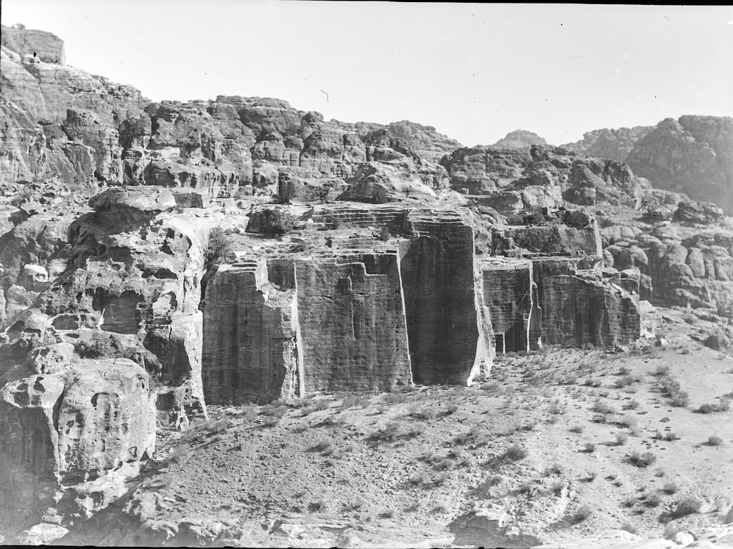 A quarry in El Barid (Little Petra), photographed in the mid 1930s. Copyright UCL Institute of Archaeology At 11.15 Drifullah brought news of an accident to one of the workmen who had his leg broken at the thigh by a fall of earth. He sat under the working face at the breakfast interval, and a short time before the whistle blew a heavy fall buried him and another man - who escaped injury. Dr Canaan returned; found the man in the police tent at Cooks Camp and set the leg. On my instruction he offered to send the man to Amman to Hospital; it was repeated several times, but he preferred to stay in the village. It is a simple fracture of the thigh. Dr Canaan improvised a stretcher – and the man was carried to his house. The digging continued, the pottery same as before with one inscribed jar handle. The lower depth is being attacked – so the depth is now six metres.
Reference: Horsfield, G. 1929 (transcribed by A. Thornton). Petra Exploration Fund Diary. "Business Papers to be Kept", Horsfield Collection Box 8, UCL Institute of Archaeology, 10 April: 30-31. [probably by Agnes Conway] A.E.C. spent the morning on Al-Ma’aisera looking at all the tombs leading to the watch-room overlooking the barred Wady Marras Hamdan outside the town. The tombs are particularly small, and there are many niches with facades too small for tombs. When above the Turkomanya Wady, I saw a line of camels which turned out to the be the last of 300 or so, which had come from Hayil, a 20 days’ journey, with 50 Wahabis to look after them. From Ma’an they went by Ain Hai and ain Khraje to El Barid, where they slept last night. They went out by El Thughra on the way to Akaba and a 5 days’ journey to Egypt to sell the camels. They said the Star Pass was too hard on the camels legs and so was the Siq. This seems to imply that El Barid may have been the last station on the way to Petra on the Southern and Eastern Trade Routes, as well as the first station from Petra on the way to Gaza. It was a first hand demonstration of the Trade Routes that we never could have hoped for, and a very fine spectacle. The afternoon went on shopping chores and consultations with Mr Read [Head] about my camera. The “Sybil” focus is all wrong and impossible to use. Reference: [unsigned, but probably Conway, A.] 1929 (transcribed by A. Thornton). Petra Exploration Fund Diary. "Business Papers to be Kept", Horsfield Collection Box 8, UCL Institute of Archaeology, 12 April: 33.
[By George Horsfield]
The whole party went to El Barid escorted by Osair. Explored the head of the 3 Wadis Ma’aisera and to the parts of the country outside the Site [? In pencil]. Noted considerable remains of ancient cultivation which is marked by the ruins of field walls and terracing. Khubet Hormuz is apparently a village – a collection of small rooms and courts on top of and down the side of a slope. It is surrounded by the ruins of ancient cultivation. The dig has progressed nearly as far as the Byzantine wall. One Byzantine lamp was found and no graves. Continued sorting pots from Katoote – which are not very distinguished; some inscribed wine jar handles and the lower fragment of a draped figurine. Reference: Horsfield, G. 1929 (transcribed by A. Thornton). Petra Exploration Fund Diary. "Business Papers to be Kept", Horsfield Collection Box 8, UCL Institute of Archaeology, 16 [15th] April, Part 1: 36-37. Note: There is a discrepancy with the dating of this entry. According to Agnes Conway's diary, the trip to El Barid occurred on the 15th April. [by George Horsfield and possibly Agnes Conway] G. H. No. 2 cave continues being cleared in the inner room which has gone more rapidly. No. 3. is cleared except for the floor – a bench of stone about 80 cents. wide existed on right side apparently running the whole length. There is a channel in rear wall to fix it in. The niche at back proves to be only 45 cents deep – purpose unknown. No more pottery. Began to dig two shaft tombs on Ma’aisera plateau – one was entered from a hole on a corner without touching shaft – Byzantine pottery fragments and nothing else so far. This No. 2. The other shaft No. 1. was filled to the brim with earth. This being cleared to 1 metre disclosed side chamber. On entering found about 10 skulls in disorder on the floor, a mass of bones – 2 pots in a corner – another near a corpse on right side and a Byzantine pot. A lot of pots came out of the shaft – including base of Rabbit Thyton with stone metal eyes – the head of a female with a hook nose – an open mouth and a crescent moon bound on her forehead. Small pots, lamps etc. A.E.C. climbed El Biyara in the morning, passing a terrace with 3 Dushara niches (given by Dalman as a sanctuary) and then going by two great inclined planes in the rock like the entrance to El Hubta. Above these, right out in the open, is a charming country house of two rooms and a terrace, with a superb view. Steps go all the way to the top, which is a long flat plateau with remains of squared stone ruins all over it, flat with the ground. I could not date them at all. The surface pottery is Byzantine, Greco-Roman, and some very rough stuff, possibly bronze age? There are six enormous cisterns; large round openings in the ground, going down deep and with stones, in some cases squared, that have fallen in from the top. Near the Arabah side of the hill and close up against another hill for shelter, is a rounded topped cave with an early plain door; date unknown. The whole hill was evidently a fastness [sic], and commands the whole country; the views are superb. The easy route from Elji to El Barid is clearly visible and the spur from it that would lead to the Edomite High Place – the first ridge of El Ma’aisera is seen absolutely crammed with buildings, the other ridges by contrast, looking quite empty. A big quarried valley seemed to lead N out of the Siyagh; the last course of the Wady Musa, through black spiky rocks, looked magnificent. Reference: Horsfield, G. [and possibly Conway, A.] 1929 (transcribed by A. Thornton). Petra Exploration Fund Diary. "Business Papers to be Kept", Horsfield Collection Box 8, UCL Institute of Archaeology, 23 April: 52-53.
[By George Horsfield]
Transported the party to El Barid for third and final visit. Spent 2 ½ hours examining site – especially the double Ba’al at W. end. This is carved from the rock in a continuation of the Sik to the West and is reached by a flight of steps about 30! Siks seem to be the product of a fissure in the [blank] sandstone which is then filled in with a perpendicular stratification which is softer and more friable – the sides have a crystalline coating of a slight thickness – one or two cents. This stratification being weaker and character wears away, hence these splits in the rocks. The El Barid is incomplete and man has manufactured an image of God out of it. The same stratification are frequently used for carving stairs out of at Petra. The image is about 6 metres high, separated on both sides from the walls - which on S side is a narrow passage – on the other narrower by which you may climb on top. The front shows a Dushara and on left Allah in the usual manner. The [sic] look roughly square from the ground and [blank] worn. The cutting between A & D is continued all the length of the rock which is some 8 metres – it is shallow about 15 cents. wide and varies in depth, never more than 30 cents. It is not straight but curves at W slightly to N. Its purpose seems to have been to isolate the images so that at the moment the solar Disk sank to this level, they would stand out black and distinct – as indeed they would to-day if a tree did not intervene. Continued on to the Numara pass passing two obelisks on left – on one pedestal carved in rock. The way was easy to find as it is a continuation of path formerly taken past Hormuz. The road is pleasant until it falls into the Wadi below phosphoritic ridge – when it becomes very difficult and tortuous. The road is used by camels for the remains of a lately dead and devoured one were seen by side of road. This journey took 1 ½ hours – found pools of water after recent rains. Returned directly to Petra and arrived back at 5.0 pm having been out 11 hours – mostly on horseback. Reference: Horsfield G. 1929 (transcribed by A. Thornton). Petra Exploration Fund Diary. "Business Papers to be Kept", Horsfield Collection Box 8, UCL Institute of Archaeology, 10 May: 72-74. |
Categories
All
Archives |
 RSS Feed