|
[probably by Agnes Conway]
Mr Horsfield spent the day completing Camp arrangements, and all the party moved in in the afternoon and slept there. In a morning of 5 ½ hours Dr Nielsen and A.E.C. visited the Tomb of the Urn, and felt certain that it had originally been a Temple (later decided it was a tomb); and was transformed into a church by making 3 apses out of the 6 Nabataean (tomb) recesses, as suggested by Irby and Mangles. They first tried to climb El Hubta by a staircase which led to El Ramleh, and noticed several places of cult by the way which do not seem to have been described by Dalman1. They then found a direct way up El Hubta and investigated the sanctuaries along the N.W. wall, described by Dalman, which form an elaborate cult centre. Byzantine pottery was found on the Watch Tower. A.E.C. climbed the most southerly lump and copied an inscription of 6 letters, looking like 1916. The language not identified 2. She was struck by the interesting views from that point, of El Ramleh from above with staircases and places of cult; of Zibb Atub with both obelisks and the castle clearly visible; and of Al Bijara, with what looked like artificial work on top, and decided to take telephoto photographs from that point if possible. A plane-table map of the top should be made, as it was left out by Brunnow, and Dalman merely deals with the individual sanctuaries. -- [Footnote] 1. These are quarry cutting remains [Footnote] 2. Nabataean Reference: [unsigned, but probably Conway, A.] 1929 (transcribed by A. Thornton). Petra Exploration Fund Diary. "Business Papers to be Kept", Horsfield Collection Box 8, UCL Institute of Archaeology, 25 March: 5-6. [By George Horsfield, Agnes Conway and Tawfiq Canaan]
G. H. Spent two hrs. with Dr. Nielsen and Miss Conway in N.W. side of El Habis examining the High Place approaches, also the underlying quarry with its tombs. Spent the rest of the morning at the dig and completed my survey of the South Wall which runs from El Habis to the Castellum in the middle, and is the highest point of the South side of the city, then to the side of Zubb Atuf on the E. In the afternoon cleaned up the high place on El Habis in part; found nothing but sane [sic] and sheep droppings covered with thin grass to a depth of 30 centimetres. Visited the dig and saw the exposed side of the wall which has appeared in it and its junction with the S wall; its outer face, in the fragment exposed, is the same as the wall which limits the Town on the Wadi Farasa. The wall in the dig projects beyond its face and is broken away, which seems to suggest that there was a Tower or at any rate a change in plane of the wall. The pottery is the same and scarce. At the side of the wall inside are the remains of another, crudely built of small shapeless stones, without a foundation, about a meter high. Three Nabataean coins turned up of the common sort with crossed cornucopias which I have often seen and sometimes bought. I have decided to go to a deeper level and shall proceed to cut off another meter from the front. A.E.C. spent most of the day making a prismatic compass plan of the circle of old unhewn stones surrounding the rock which she found on March 28th. J. [sic] B. Canaan: Before noon went through the siq to Wadi-el-Muslin, followed its course and the course of its tributaries up to Wadi-el-Mataha. Made a plan of the Siq, el-Mataha and the surroundings. Reference: Horsfield, G., [Conway, A.] and Canaan, T. 1929 (transcribed by A Thornton). Petra Exploration Fund Diary. "Business Papers to be Kept", Horsfield Collection Box 8, UCL Institute of Archaeology, 3 April: 21-22. [by George Horsfield and possibly Agnes Conway]
G. H. The dig proceeded slowly and has advanced into the debris about 2 metres beyond the W. side wall – at a depth of 4 ½ metres from the summit, 3.50 m below the top of wall. Pottery has come out more freely and the limit of the finer pottery is passing. To-day 4 baskets fairly full appeared consisting of large round handles and fragments of wine jars, cooking pots and a few fragments of terra sigillata, which I think are of the beginning of the 1st century AD. I have decided to stop the work here for a day or two and have arranged to divide the working party in order to dig into the two mounds lying between Ez Zantour and Zubb Abuf [sic] – so as to have some comparative material. These mounds are very puzzling as they seem early 2nd and 3rd century and would suggest that this part of the city was abandoned at this period and used as a dump for household debris. I began to examine the North area of the city between the Wadi Ma’aisera and Hubda – beyond Wadi Musa. It is extremely difficult to form an opinion of its extent in an early period towards the North. There is the appearance of a defensive wall inside the inhabited area which continues to the Wadi Ma’aisera then turns South following its left bank and is lost in the ruins of what appears to be a Hadrianic building with columns and a court to the S. I could not find the point where it crossed the Wadi. In front of this at about 15 metres N. is another wall of slight construction, which appears as a heap of stones which does not seem to go anywhere. At the end are the foundations of a large building standing out from the wall to the N. which looks as if it were the base of a Tower – or it may be only the foundation of a lost building – it is built of red standstone, I think the ordinary paving stone, which is seen in many places, lying about in disorder on the ground and others outlining graves which are orientated roughly E. and W. The area examined is well covered with ruins which appear to be classical in character – with columns, drums and bases –of well-built material like the Kasr-el Bint. They seem to have suffered changes and alterations. There are signs of rough terracing to walls which suggest that this part also has been cultivated at some later date. I noted that some of the fields seem to have been irrigated on the S side, the water probably having been brought from the site before the complete breakdown of the canalisation system. A.E.C. spent some time at the dig with Mr Horsfield, and went on to the Farasa West valley. There she saw what looked like unrifled tombs near the ceiling of the Greco-Roman Tomb Br.[unnow] 257. She was puzzled by the water arrangements in connection with Br.[unnow] 228, and the water-channel in what ought to be a cistern next door. The interiors of some of these tombs need photographing as types, particularly the pilaster panelling of Br.[unnow] 228 and 253. The closed glen leading to 228 with the block at the end and the cisterns above is a most attractive enceinte and full of greenery; and the swanky grave courtyard of 257 is charming. The white shaft grave area on the way to it with stibadia etc seems queer and old by comparison. An attempted study of the facades is not leading to much at present, and the interiors are proving more interesting. Spent the afternoon trying to find the way up Jebel en Numer, and walked a long way up the Wadi Umm Ratam and back by the Thughra. In an isolated spot near the Umm Ratam was one rock cut grave in a wonderful position – otherwise the walk was free of all monuments! Found one doubtful flint implement. (Mousterian). Reference: Horsfield, G. [and probably Conway, A.] 1929 (transcribed by A. Thornton). Petra Exploration Fund Diary. "Business Papers to be Kept", Horsfield Collection Box 8, UCL Institute of Archaeology, 7 April: 26-29. [possibly Agnes Conway] Mr. Horsfield and A.E.C. went to see the house opposite the theatre, and the Tomb of Onaisu, from which Mr. Horsfield hopes to get the chronology of the Tombs straightened out. He noticed a new type of crenellated tomb in the site, where the crenellations are real battlements. There is an intermediate form of tomb in the Outer Siq in which the crenellations come to the top, but have no cornice. The house has remains of painted plaster in one room, in a recognizable design, and the room is vaulted. They went on to Zibb Atuf, and agreed that the obelisks were connected with the quarry and had nothing to do with the Place of Sacrifice. Mr H. thought the entrance towers Byzantine, and the two on a lower level of a different date, but could not understand them as fortifications. 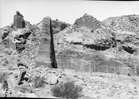 Obelisk on Zibb Atuf, photographed in 1927. Copyright UCL Institute of Archaeology. He thinks the cut stone on the rim of the altar of the Great High Place implies some superstructure and suggests that it was a shrine rather than an altar; made perhaps to hold some sacred stone emblem of Dushara which may have stood on the base of the so-called altar of burnt offerings. Such a stone might easily have been thrown down the hill side. From the stone cutting of the triclinium (?) wall, he thought the work was of the 1st century B.C. Should the altar be a shrine, A.E.C. thought the victims might have been slaughtered beside the round basin, in which the blood might have been collected and poured on the sacred stone. In this case why should a runnel join the round basin to drain liquids into the court?1 On the way up above the theatre they reached the plateau where the snake relief is (better photograph needed). Mr H. thought this must be a shrine; but the surrounding caves are all houses; some of them very fine ones. The whole lot are included by Dalman as the 2nd sanctuary of the Theatre-berg! In the afternoon they visited the silted up caves in the Wady Ma’aisera el Gharbiyah and decided which should be dug tomorrow.
__ [Footnote] 1. A later dig showed that it did not drain into the court, but ran down the mountain at the back. Reference:[unsigned, but possibly Conway, A.] 1929 (transcribed by A. Thornton). Petra Exploration Fund Diary. "Business Papers to be Kept", Horsfield Collection Box 8, UCL Institute of Archaeology, 19 April: 44-45. [possibly Agnes Conway]
A.E.C. and Dr Nielsen went to Zibb Atup [sic] with 3 men to dig out the cistern. It proved to be full of water, so after they had baled it out they went away, as it was impossible to retrieve any pottery from the mud. She and Dr Nielsen visited the quarry, agreeing that the obelisks had nothing to do with the Sanctuary. A.E.C. photographed the Byzantine pots and found two cisterns on the E side towards which the baled out water had poured. They returned by the N. route; Dalman’s Processional Way; but had to be carried by Mahmud to the 2nd terrace, where the snake shrine is, and again to ground level. Dr Nielsen revised his view of the moon-shrine and thinks it too far from Zibb Atup [sic] to have anything to do with the Sanctuary. A.E.C. photographed all the afternoon from the Edomite High Place. Reference: [unsigned, possibly Conway, A.] 1929 (transcribed by A. Thornton). Petra Exploration Fund Diary. "Business Papers to be Kept", Horsfield Collection Box 8, UCL Institute of Archaeology, 2 May Part 2: 65-66. [possibly by Agnes Conway]
Mr Horsfield went to Maar [sic] to get money and started packing pottery. AEC went to Zibb Atuf and got the larger cistern dug out. She brought back all the fragments of pottery, which include most of the types from Byzantine to Nabataen and Greco-Roman already found here. She then dug a square yard in front of the small cistern to see whether there was an artificial channel for the liquids from the round altar. A wall 50 centimetres thick was found running at right angles from the corner of the cistern to the natural stone. Immediately in front of the cistern, at the 40 cm level, a stratum of burning was struck, full of burnt pottery, which Mr H declared to be Nabataean. The outflow of the liquid must have been stopped by the wall, one stone of which is still in position standing above the ground. She went down by the S. way to the Wady En Mer and the Hrabet-en-Mer, where the Obodat inscription is. This shrine to the Divine Obodat, if it is one, looks exactly like a house. What Dalman calls a statue and which should probably be translated “image” is clearly an omphalos in a niche; the spot above it, said by Dalman to be the hollow for the upper part of the statue, being the last remains of the fine tooling of the niche above the omphalos. The stone on which the inscription is, occupies the position of a 9 inch vertical beam in relation to the ceiling, and covers two yards to the front of the niche. The beam, squared and tooled its whole length where it is not inscribed, as well as on the bottom face, has apparently been broken off to the left of the inscription, and forms an integral part of the ceiling, which, elsewhere, is extremely roughly tooled. The walls are delicately tooled and squared. The omphalos looks like the Dushara symbol commonly employed at Bostra on the coins. If so, the Divine Obedat was worshipped as Dushara. Does the inscription imply that it was put up by a private family in their private house? That is what it looks like. Photographed the Stibadium house above the Siyagh and finished planning the excavated Siyagh house. Reference: [unsigned, possibly Conway, A.] 1929 (transcribed by A. Thornton). Petra Exploration Fund Diary. "Business Papers to be Kept", Horsfield Collection Box 8, UCL Institute of Archaeology, 8 May: 71-72. |
Categories
All
Archives |
 RSS Feed